Parks planning is benefiting from GIS, a technology designed to collect, integrate, and analyze diverse data and generate information-rich, computer-based maps of a given project area. GAI Senior Project Planner Patrick Panza, AICP, and Senior Planning Manager Kristin Caborn, CPRE, FCP speak with us about GIS and how it came into play during GAI’s work on the Casselberry Parks and Recreation Master Plan for the City of Casselberry, Florida.
Geographic Information System (GIS) technology has emerged in recent years as a vital tool for helping communities make informed decisions during parks and public-space planning. If you ask GAI Senior Project Planner Patrick Panza and Senior Planning Manager Kristin Caborn, the GIS advantage is all about understanding ‘relationships’–how people, services, and accessibility interact, and working to create better public spaces based on the real conditions affecting the people who will use them.
GIS creates clear and accurate visualizations that empower planners, engineers, and project owners to make informed decisions based on high-quality, meaningful data.
Some quick background: GIS technology is designed to collect, integrate, and analyze diverse data and generate information-rich, computer-based maps of a given project area. Taking in data like population, topography, services, structures, permitting, roads, and point-to-point travel times, GIS creates clear and accurate visualizations that empower planners, engineers, and project owners to make informed decisions based on high-quality, meaningful data. GIS maps can be updated in real time with data collected in the field using mobile computing devices.
GAI utilizes GIS technology in project areas including community design and parks planning, road building and maintenance, natural gas and mining development, electric generation and transmission, environmental impact studies, archeological investigations, and much more.
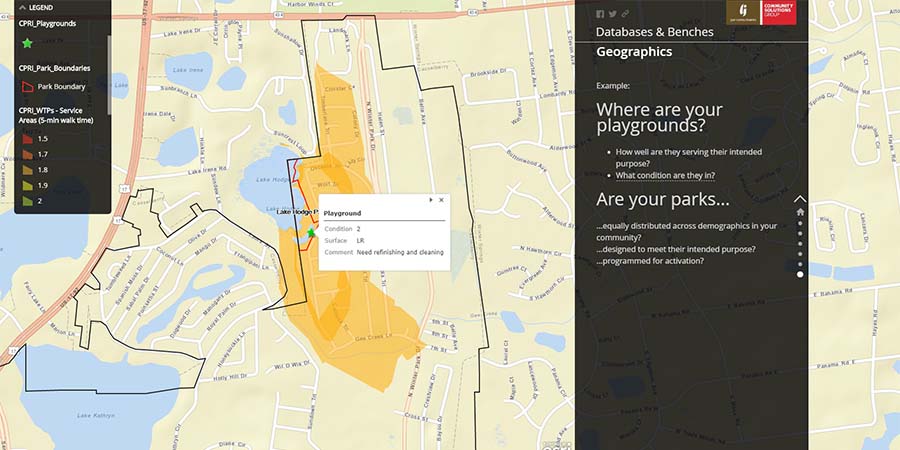
We caught up recently with Patrick and Kristin, who were fresh from delivering a presentation about GIS applications in parks planning titled “Databases and Benches: A Love Story” at the 2017 Florida Recreation and Parks Association (FRPA) conference.
Q: What message were you looking to deliver in your recent GIS presentation?
Patrick: We were speaking primarily to people involved in and responsible for delivery of their communities’ parks and recreation services. A key factor for making sound and effective decisions when undertaking public-space projects large or small is having a clear, accurate, and current inventory of all your assets—roads, benches, buildings, playground equipment, and more. Basically ‘good data’ with which to determine your needs and base your plans for development and improvement. Not only can GIS data gathering can be performed on-site using handheld devices, the technology instantly integrates the new information into the project database.
Kristin: GIS is a real boost not just to efficiency, but accuracy as well. GIS mapping was the primary tool used during GAI’s Community Services Group’s work on the Casselberry Parks and Recreation Master Plan for the City of Casselberry in Seminole County, Florida.


Q: How did GIS technology help with the Casselberry Parks and Recreation Master Plan project?
Kristin: In projects like this—initiatives that aim to create public spaces that are optimized to serve the local population—real, qualitative data is essential. Walkability, for instance. Many park users will access the facility on foot—and it doesn’t offer a clear picture to know that an access path is ¼ mile long if we don’t know that the path is in poor condition, prone to flooding, or crosses a major roadway. Can a mom walk with her kids? Can a person who requires special access use the path? GIS data—in the case of Casselberry, including photos of the assets described—lets us assess real conditions on the ground. Add GIS’ incorporation of data about the local population and the way people historically move through and around the spaces mapped, and a true picture of public-space needs and solutions begins to emerge.
Patrick: GIS is powerful—and, as I mentioned, it’s fast. During the Casselberry project, inventory photos were uploaded as assets were cataloged by staff in the field, building a database rich in information about quantity, condition, and location. The resulting layered GIS maps showing how all the parts fit together were available in near real time.
Kristin: We used the GIS maps to demonstrate our findings and help generate Casselberry’s Master Plan. We incorporated extensive public input received through a series of focus groups, open public meetings, a steering committee, meetings with staff and elected officials, and online surveys. GIS technology was a great tool for telling the story of the current condition of Casselberry’s parks and communicating our shared vision for future improvements. But just as important, GIS will be a great tool for the City of Casselberry on an ongoing basis now that the technology is in place for future community projects.
Q: It’s clear that Casselberry benefited from GIS technology—do you think attendees at the FRPA conference benefited from your GIS presentation?
Patrick: Oh, I think so. Our objectives for the presentation were to describe the ways GIS can be used to communicate a range of statistics to the public and elected officials, show how the GIS data could be collected using everyday mobile devices, and demonstrate how the resulting interactive GIS maps told the story of how well a given park meets the community’s needs and expectations. We took a lot of good questions that demonstrated pretty clearly that the attendees were engaged and took some value from the discussion.
Kristin: And we actually got a thank-you note from someone …
Patrick: Yes – we got a handwritten thank-you note, mailed to the office old-school style. It says, “Thank you so much for helping me to learn a bit more about what GIS can do for [my community] at the FRPA conference. I went out of my realm taking that session—and I’m so glad I did.”
Kristin: That was really nice to hear. And I think it is proof positive that many communities might not yet realize why GIS technology is important to integrate into their processes.
Please feel free to write Patrick or Kristin and find out how GAI can implement GIS technology to help with your parks planning or other community design project.
 GAI Senior Planning Manager Kristin Caborn, CPRE, FCP has 17 years of extensive parks and recreation management and planning experience. Contact Kristin for more information on how GAI can help with your community’s park-planning project.
![]() GAI Senior Project Planner Patrick Panza, AICP has more than 10 years of experience specializing in planning, design, and policy analysis. Contact Patrick for answers to your questions about GIS technology or to learn more about GAI’s planning services.
GAI Senior Project Planner Patrick Panza, AICP has more than 10 years of experience specializing in planning, design, and policy analysis. Contact Patrick for answers to your questions about GIS technology or to learn more about GAI’s planning services.
Read more about GIS technology at GAI:


