In a major revitalization effort, Charleston, WV is transforming its downtown core into one of the nation’s foremost pedestrian-friendly cities. The city’s urban renewal plan combines the notion of Road Diets with consistent landscape design elements, creating an ultimate experience for the pedestrian.
In the 1960s-70s as residents across the nation moved to the “greenfield” suburbs, transportation engineers and city planners envisioned downtown areas as “Central Business Districts” (CBDs). Automobile efficiency was key. One-way roads, road widenings, extended expressway ramps, and higher speed design focused on moving AM and PM commuters in and out of the city quickly—all at the expense of the walkability or character of downtown.
That CBD vision is no longer relevant today—downtowns are not socially or economically sustainable as single-use office centers. When residents left for the suburbs, retail and ultimately office space followed and most CBDs were never “built out” as envisioned.
Now, planners realize that sustainable downtowns require a combination of uses including residential, which supports retail and makes the downtown a more desirable location for a market driven office population. It should be a mixed-use, attractive environment with access and proximity to a vibrant “live, work, play” lifestyle.
Walkability, however, needs to be a top consideration to improve this unsafe urban condition. Residents and daytime pedestrians of successful downtowns need to feel safe to walk or bike without fear of being struck by a vehicle. Crossing a multi-lane one-way street in a city is often difficult, if not impossible, especially when traffic is heavy and speeding. The goal now is to promote safe, walkable access to all the amenities afforded by downtown living.
Enter the concept of a Road Diet.
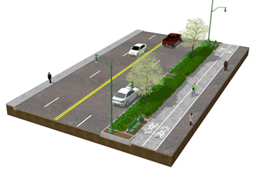
“A Road Diet means reducing the number of lanes or the width of lanes to calm traffic and better support both pedestrian mobility and economic development goals for downtown,” said GAI Sr. Landscape Architect Jacob Burns, PLA, ASLA. “By reducing road width, we improve pedestrian safety and create better walking, biking, and retailing experiences for pedestrians in our cities.”
As more communities seek safer, more livable environments, the concept of a Road Diet is catching on. In a series of 24 case studies across the US, the Federal Highway Administration (FHWA) exemplified the benefits of Road Diet implementations. “Road Diets are win-win for the community and the people who live there,” said Burns. “With narrower roadways, vehicles are forced to slow down and people can walk or bike with greater safety. It also gives more room for things such as wider sidewalks, pedestrian islands, crosswalks, bike lanes, green space, and even ‘Main Street’ style outdoor retailing and dining.”
In its recent strategic urban renewal plan update for the City of Charleston, WV, GAI’s Community Solutions Group recommended several techniques that the City could explore such as Road Diets, Traffic Calming and street reconfigurations, with the intent to make traffic more pedestrian and business friendly in the downtown area. The report noted that one-way traffic and excessive street width encouraged motorist speeding and inhibited pedestrian activity.
Successful downtown main streets typically enjoy significant pedestrian traffic with cars operating speeds of less than 20 miles per hour. One-way streets, especially one-way road pairs of 10 to 15 blocks in length, tend to encourage higher operating speeds (about 35 to 40 miles per hour) and many more turning movements.
GAI also recommended the need to further study the current traffic patterns in the downtown core. By converting some of the one-way streets to two-way and reducing the width of the lanes, traffic is slowed down, pedestrians could walk and cross more safely, and the downtown becomes more intuitive in terms of navigation and wayfinding.
The City of Charleston, WV: Making Connections
As part of its urban renewal and pedestrian friendly focus, the City of Charleston, WV is undergoing an amazing transformation. From an urban design perspective, GAI is helping the city unify the look and feel of the downtown core by using common design elements.
In 2014, GAI began a master planning effort for Brawley Walkway and Slack Plaza in downtown Charleston. Brawley Walkway provides a vital pedestrian connection from Capitol Street—Charleston’s most vibrant and charming street—to Court Street, another popular street in Charleston that also marks the east entrance to the Town Center Mall. Slack Plaza sits at the halfway point between the two nodes, and connects with Laidley Street, which is home to Charleston’s transit mall.
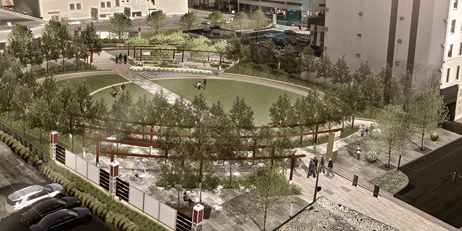
Construction of the first stage of the project, Brawley Walkway, is nearing completion. The revitalized walkway is now wider and more inviting, and uses repeated materials throughout to help subtly draw pedestrians from one side of the corridor to the other.
GAI is also involved with construction for the Charleston Civic Center renovation and expansion, currently underway. To create a safe and attractive pedestrian thoroughfare, the final plan includes a total rethinking of how Clendenin Street functions from a pedestrian aspect. One of these projects includes installing an elevated crosswalk that connects the Civic Center to the Town Center Mall.
“We’re using the same pavers in the crosswalks at the Civic Center that we used on Brawley Walkway,” said Burns. “By repeating materials and design elements, we visually connect the city.” The paver pattern on the crosswalk also helps to create a visual break in the pavement, alerting drivers of the pedestrian crossing.
Clendenin Street is now nearing completion of its Road Diet, which includes an elevated crosswalk connecting the Charleston Town Center to the new $100 million renovated Civic Center discussed previously. Retail friendly on-street parking was created by reducing the corridor from four driving lanes down to two. The two “abandoned” lanes were repurposed and converted to on-street parking with wider sidewalks in an effort to “activate” the corridor by attracting new retail and restaurants along the corridor. The paver pattern breaks up the road and indicates to drivers to slow down for pedestrians in the walkway.

“This is a critical project for the City of Charleston because it is the first major attempt by the City to use some of the traffic calming concepts we outlined in the recently adopted strategic plan into a real, tangible project,” said Burns.
Clendenin Street will also serve as a critical node along the pedestrian spine that will ultimately connect the downtown’s historic and business core to the newly revived entertainment district, which is being spurred by the ongoing renovation to the Charleston Civic Center.
“From an urban design standpoint, it’s exciting to see these concepts come to life,” said Burns. “With the promise of the Civic Center renovations, we have already seen new business locate to the area such as Starbucks and the new Courtyard by Marriott. These upgrades to Clendenin Street will only aid in amplifying the pedestrian experience throughout this corridor.”
Continuing Efforts Focused on the Pedestrian
With construction underway on the Charleston Civic Center and associated adjacent streets and waterfront, pedestrian friendly efforts continue for the downtown core. “Our work is focused on the experience of arrival, outdoor gathering, and adjacent urban development,” said Burns.
At the Civic Center, a significant component of GAI’s work involves the complete redesign of the Quarrier Street and Civic Center Drive entrance plaza. The design solution improves several key elements:
- Resurfacing Civic Center Drive with pavers to reinforce it as a pedestrian access point
- Separating the drop-off area from the driving lanes
- Relocating the ADA parking to allow easier ingress and egress
- Increasing the amount of green space
- Reconfiguring the circulation pattern
GAI is performing site, civil, and landscape architecture for this $92 million project, as well as designing a new riverfront park and trail connection along the Elk River that will soon connect the Civic Center to the Kanawha River and beyond. When all phases are completed, Charleston, WV can be on the list as one of the nation’s premier livable cities … a pedestrian’s dream, indeed.
GAI’s Community Solutions Group is a diverse and growing team of experienced planners, designers, economists, and public policy experts. The Group integrates landscape architecture, urban planning, economics, and finance in an idea-driven strategic consulting practice.
For questions or additional information about the Charleston, WV project, contact Sr. Landscape Architect Jacob Burns, PLA, ASLA at 681.245.8858.


