Connecting Mobility, Place, and Community Value
Key Takeaways
- Complete Streets initiatives create safer, more accessible travel by planning for people using all modes of transportation.
- Complete Streets function as public places that support development, community life, and broader place-based goals.
- Effective Complete Streets planning aligns community needs, funding, design, and implementation.
Every community has streets, but the best streets do more than move people and goods. Over the last two decades, more than 1,700 Complete Streets policies have been adopted across the United States, reflecting a shift in how communities think about streets, mobility, and public investment.
Complete Streets work best when streets are treated not only as transportation corridors but also as public places that shape movement, development, identity, and everyday community life. GAI brings its transportation and civil engineering, urban design, landscape architecture, and community development expertise together to help communities turn street investments into improved mobility, better access, and more connected places.
From Vision to Action
The following projects show how Complete Streets initiatives can improve access, strengthen public space, and support long-term community priorities. Across communities, the strongest examples connect transportation needs with redevelopment goals, public space improvements, funding realities, and daily use.
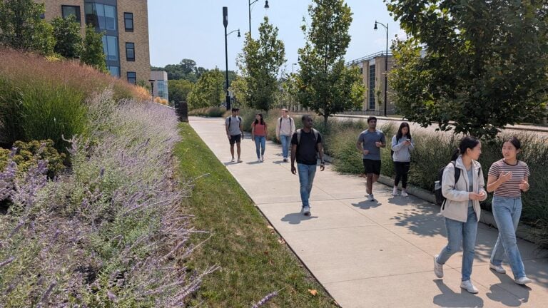
Along Carnegie Mellon University’s campus, Forbes Avenue was becoming more than a vehicular route as new academic buildings and housing brought increased foot and bike traffic. Narrow sidewalks, limited separation between pedestrians and vehicles, parking demands, and accessibility and traffic signal issues complicated travel throughout Forbes, Morewood, and Fifth Avenues.
Working with CMU’s Campus Design and Facility Development department, GAI built upon earlier streetscape work and the university’s Pedestrian Safety and Mobility Study to create a phased plan for pedestrians, cyclists, drivers, and transit users. The team shaped the findings into a practical sequence of corridor upgrades and supporting material for CMU’s state grant application.
The plan did more than identify street improvements; it created a practical path from planning to construction. CMU’s successful application secured $300,000 to help advance the work, showing how Complete Streets can bring together pedestrian safety, travel options, future growth, and funding to help a growing campus feel and function as one connected place.
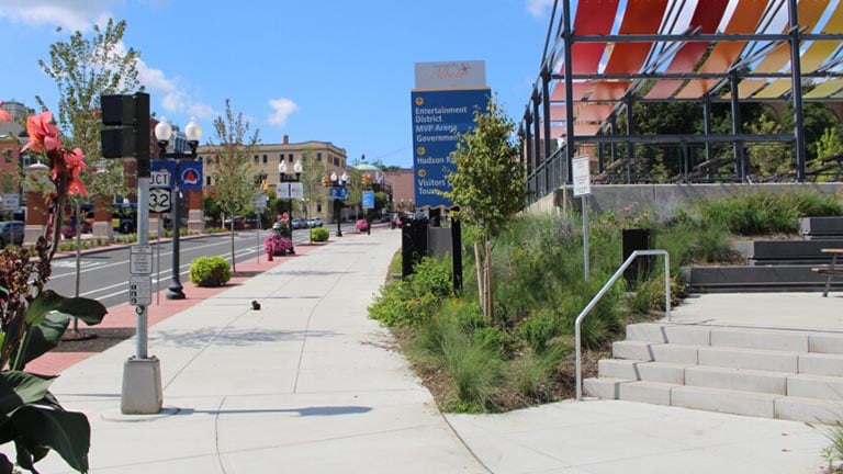
On Clinton Avenue in downtown Albany, a short gap created an outsized challenge. Although bicycle facilities already extended west along Clinton Avenue, they ended two blocks short of the Albany Skyway. The missing segment between Broadway and Ten Broeck Street disrupted a continuous route between downtown and nearby neighborhoods and onward to the Albany Skyway and Empire State Trail.
Working with the City of Albany, Creighton Manning, GAI’s New York Transportation & Infrastructure business sector, guided the project from analysis and public engagement through design and construction. The redesign closed the gap with bicycle lanes, accessible pedestrian infrastructure, and safer crossings. Streetscape and gateway improvements helped make the connection a more visible part of downtown.
Together, the improvements have turned a missing link into a critical multimodal connection. Residents, commuters, and visitors gained better access to adjoining neighborhoods, downtown destinations, the Hudson River waterfront, the Albany Skyway, and the broader trail network. The project shows how a focused two-block investment can complete a larger transportation system while giving downtown revitalization a visible presence at street level.
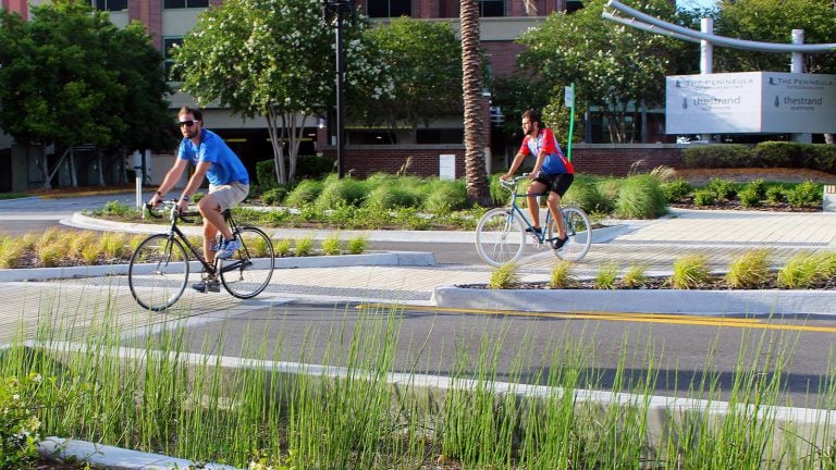
Riverplace Boulevard runs through Jacksonville’s Southside Community Redevelopment Area, where development activity had reshaped the riverfront. The area includes high-rise residences, offices, dining, entertainment, and ongoing redevelopment sites. Yet the street still reflected an earlier era: five vehicle lanes carried relatively low traffic volumes, leaving the corridor out of step with the more urban, mixed-use environment emerging around it.
Working with the City of Jacksonville, GAI led public involvement that helped guide selection of a preferred design reducing the roadway from five vehicle lanes to three. Reclaiming that space created room for safer bicycle and pedestrian movement, on-street parking, transit access, and green infrastructure. The redesigned public realm strengthened the street’s role as a multimodal corridor and supported ongoing redevelopment, with GAI’s landscape architecture, civil engineering, and transportation engineering teams carrying the concept through final design.
The reconstruction brought the street into alignment with the transformation already occurring around it. Riverplace Boulevard continues to serve transportation needs while supporting improved access to the Southbank Riverwalk and surrounding redevelopment area. The project later received a 2021 Florida Redevelopment Association Roy F. Kenzie Award and a 2022 American Society of Landscape Architects (ASLA) Florida Award of Merit for Urban Design.
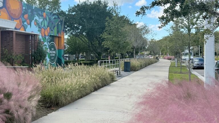
Orlando’s Packing District began as a citrus-processing and industrial area. As the district moved toward a mixed-use, walkable future, its streets also had to change. Corridors built around industrial traffic needed to become the transportation framework for new homes, recreation facilities, and parks. They also needed to connect community destinations and public spaces.
Working with Dr. Phillips Charities and the City of Orlando, GAI’s landscape architecture and civil engineering teams helped reshape the streets for the community taking form. Reducing a one-mile section of Princeton Street from six lanes to four created space for on-street parking and separated bicycle facilities, while a walkable, landscaped streetscape connected the transportation improvements with broader district infrastructure and development. A similar adjustment was made to a 2,000-foot segment of SR 441, which intersects Princeton Street in the heart of the redevelopment area.
The result was not an isolated roadway project, but a street network prepared to support a new urban community. The completed Princeton Street streetscape marked an early step in that evolution, replacing an industrial pattern with safer, more accessible connections and demonstrating how Complete Streets can establish the framework for broader transformation.
The Complete Streets Opportunity
The larger opportunity in Complete Streets initiatives is to use street investments to strengthen mobility, place, and lasting community outcomes. That requires understanding how a corridor functions, what the surrounding place needs, and how each investment can move from planning intent to implementation.
For GAI, the opportunity lies in bringing transportation planning and engineering, civil engineering, urban design, and landscape architecture expertise together from the outset. That integrated approach helps communities connect corridor planning, funding, design, and implementation, so each street investment advances both mobility and broader community goals.
When planned through that broader lens, Complete Streets can help communities create safer corridors for all modes of transportation and more connected places by improving the streets that people use every day.
These GAI company professionals are representative contributors to the successful Complete Streets projects highlighted in this article. For more information about GAI’s planning, transportation, and civil engineering services, contact Blake Drury, 321.319.3125, Tony Christian, 518.689.1880, James Yost, 681.245.6482, or Matthew Bolyard, 904.559.8086.
 Tony Christian, PE has extensive background delivering roadway, pedestrian, bicycle, and complete streets projects across New York. In his role as Highway Group Leader and project manager at Creighton Manning Engineering & Surveying, a GAI company, Tony leads assignments from design through construction support, with expertise in corridor and intersection improvements, roundabouts, ADA-compliant facilities, multi-use paths, drainage, streetscapes, and public engagement.
 Matthew M. Bolyard, PE has more than 20 years of experience delivering transportation, water and wastewater, stormwater, and other public infrastructure projects. As a project manager and engineer-of-record, he leverages expertise that includes roadway and utility design, drainage, complete streets, streetscapes, shared-use trails, transportation planning, and traffic engineering.
 James Yost, PLA, ASLA serves as Sr. Landscape Architect Manager in GAI’s Charleston, WV, office where he coordinates a range of landscape architecture, planning, and solar energy projects throughout the firm’s northeast operating area. As part of GAI’s Community Solutions Group, James applies more than a decade of experience on a diverse scope of projects for both the public and private sectors.
 Blake Drury, AICP specializes in urban design and city planning focused on creating livable communities. He has developed plans for public-sector clients in urban, suburban, and rural settings across North America, including design of large-scale neighborhood redevelopment projects, downtown plans, and transit station area planning programs. Blake has extensive experience helping clients develop master plans for traditional neighborhood development design projects throughout the southeastern United States.